HeaRTNovation
D-HIVE: Development of Health Index and Vulnerability Reduction System for Region 4B (D-Hive 4B Capital)
Technology Generator
Mapua University
Project Leader: Dr. Delia B. Senoro
The Problem
Having endured around 283 natural disasters over the past two decades, the Philippines is regarded as one of the most-disaster prone countries in the world. The Philippines is a common pathway of tropical storms and it sits on the Pacific ring of fire – a Pacific belt of active volcanoes that exposes the country to several daily minor earthquakes.
Anthropogenic activities further aggravate health risks brought by continued exposure to natural disasters. For example, Marinduque Island, which is known for its significant amount of copper reserve, is a site for a number of mining activities. Due to uncontrolled circumstances, Marinduque suffered two mining disasters in 1993 and 1996 and these were considered as among the most disastrous events in the global mining industry. This caused pollution in the water and land resources of the island province, and ultimately caused public health risks and concerns.
Efforts to mitigate disaster and health risks have long been in place. Several frameworks have been developed by other researchers over the past years to measure vulnerabilities to climate change. However, these frameworks were conceptualized based on geographical roots and natural disasters research and a variety of other research contexts such as ecology, poverty and development, sustainability science, and related others. The risks and vulnerability reduction framework of a locality has to be anchored specifically on disaster event/s onto which the communities are exposed to regularly, the geographical location of the communities, and regional cultural conditions for it to be effective.
The Solution
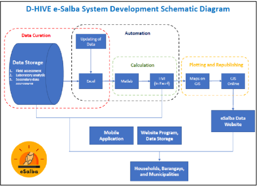
 The Resiliency and Sustainable Development Center of Mapua University – Manila, in collaboration with various higher educational institutions, Department of Health – Health Emergency Management Staff (DOH-HEMS), and the disaster risk reduction and management groups in MIMAROPA, and through the funding support of the DOST-Philippine Council for Health Research and Development, developed a communication and monitoring tool for five (5) participating areas in the region. This communication and monitoring tool is a health vulnerability reduction system called eSalba.
eSalba is a communication tool that serves as an early warning, monitoring, and emergency response system. It has three tools: (1) health vulnerability index (HVI) for three geopolitical units, (2) health risk maps, and (3) a mobile/web-based application that can be used before, during, and after natural and/or anthropogenic disasters. The system has the capability to show which areas in the communities have, or potentially have metals contaminations, and the level of concentrations of contaminants in groundwater, surface water, soil, sediments and agricultural yields. It also provides information on areas that have high health risks and the risk level categories of communities.
The system is envisioned to help local government units (LGUs) in improving disaster and health resilience capabilities of 54,000 households in the island province, and four other areas in MIMAROPA. It also serves as a guide for LGUs in creating strategic programs to mitigate identified health risks in their respective localities.
Technology Development Status
eSalba is currently at Technology Readiness Level (TRL) 7. Three copyright registrations have been secured for the eSalba system.
Current Needs
The technology owner is actively seeking developmental funds to scale up the development of eSalba
Contact Information
KNOWLEDGE & TECHNOLOGY TRANSFER OFFICE
G/F Yuchengco Innovation Center
Mapua University
658 Muralla St., Intramuros, Manila
Person-in-charge: Dr. Jonathan W.L. Salvacion
Email Ad: jlsalvacion@mapua.edu.ph
dbsenoro@mapua.edu.ph


